Spatial and Temporal
Patterns of Archaeological Looting

Abu Simbel Temples, Egypt
Photo by AussieActive on Unsplash

DESCRIPTION

This project seeks to understand patterns of archaeological looting in Lower Egypt and how the broader contextual factors influence these patterns. Not only has there not yet been extensive scholarship to understand the link between looting and contextual forces, there is a dearth of research on the most effective ways to study these interconnected variables. Using a framework of routine activity theory, this project proposes a new possible approach that considers spatial, temporal, and spatio-temporal relationships to establish baseline data on patterns of archaeological looting attempts in Lower Egypt from 2015 to 2017 relative to sociopolitical, economic, and environmental stress. Specifically, it proposes a methodology for collecting and coding data on archaeological looting attempts from satellite imagery and then applies a series of spatial (clustering, proximity), temporal (SEM, VAR, ARDL), and spatio-temporal methods (clustering, hot spots analysis, spatial time series) to these data to demonstrate the importance of analyzing this phenomena multidimensionally.
go to dissertation

DATABASE

This database contains 994 incidents of attempted archaeological looting at 140 archaeological sites from 2015 to 2017 in Lower Egypt. Each row in the data represents a month-year and archaeological site location. Incidents of looting were identified and coded from 3,199 satellite images. The data can be explored by method of defining looting as well as by site and time period.

looting dataset

These data contain 994 incidents of attempted archaeological looting across 5,040 possible site-months at 140 archaeological sites from 2015 to 2017. Variables include both temporal and spatial locations as well as multiple operationalizations of archaeological looting. Additional details on the coding methodology are available upon request.
REQUEST ACCESS

CONFLICT DATASET

These data contain 1,218 incidents of conflict (sociopolitical stress) in Lower Egypt from 2015 to 2017. Variables include both temporal and spatial locations as well as multiple measures of conflict (all, violent, nonviolent, violence against civilians, protests, terrorism, religious violence, police-militant clashes, riots, and other. Conflict incidents were compiled from the Armed Conflict Location and Event Database (ACLED) and the Global Terrorism Database (GTD). Additional details on the coding methodology are available upon request.
REQUEST ACCESS

ECONOMIC DATASET

These data contain monthly economic indicators of stress at the governorate level from 2015 to 2017. Variables include consumer price index (CPI) (food, general, & inflation); total unemployment (national and governorate); youth unemployment (governorate); short term debt (external & reserve); and international tourism arrivals. Economic indicators are sourced from Egypt’s Centralized Agency for Public Mobilization and Statistics (CAPMAS), the Food and Agriculture Organization (FAO), and the World Bank. Additional details on the coding methodology are available upon request.
REQUEST ACCESS

ENVIRONMENTAL DATASET

These data contain monthly environmental indicators of stress at the governorate level from 2015 to 2017. Variables include temporal and spatial locations, average soil moisture content, average NDVI, average precipitation, and crop production. Environmental indicators are sourced from the National Aeronautics and Space Administration (NASA), the National Oceanic and Atmospheric Administration (NOAA), and the Food and Agriculture Organization of the United Nations (FAO). Additional details on the coding methodology are available upon request.
REQUEST ACCESS

CODEBOOK

Detailed codebook containing the specific definitions and operationalizations for each variable across the four datasets above.
REQUEST ACCESS

Data visualization gallery

Findings and research dissemination activities

FORTHCOMING
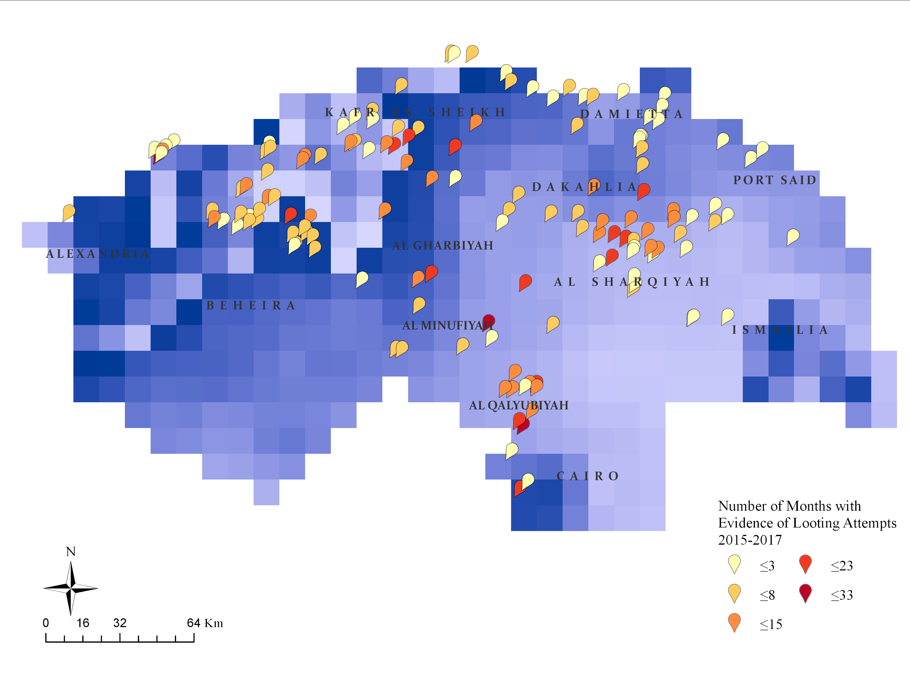
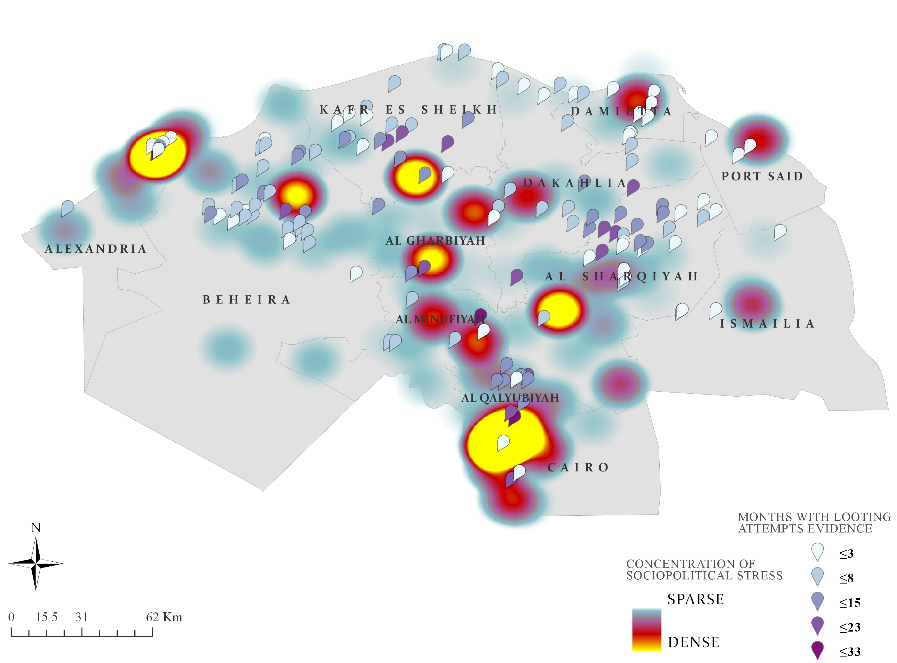
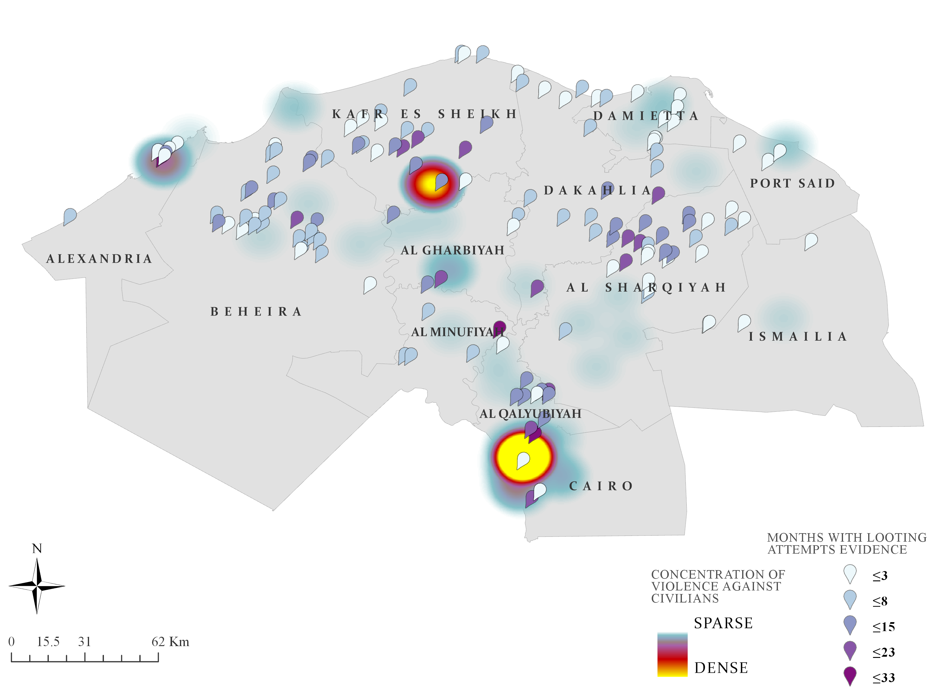
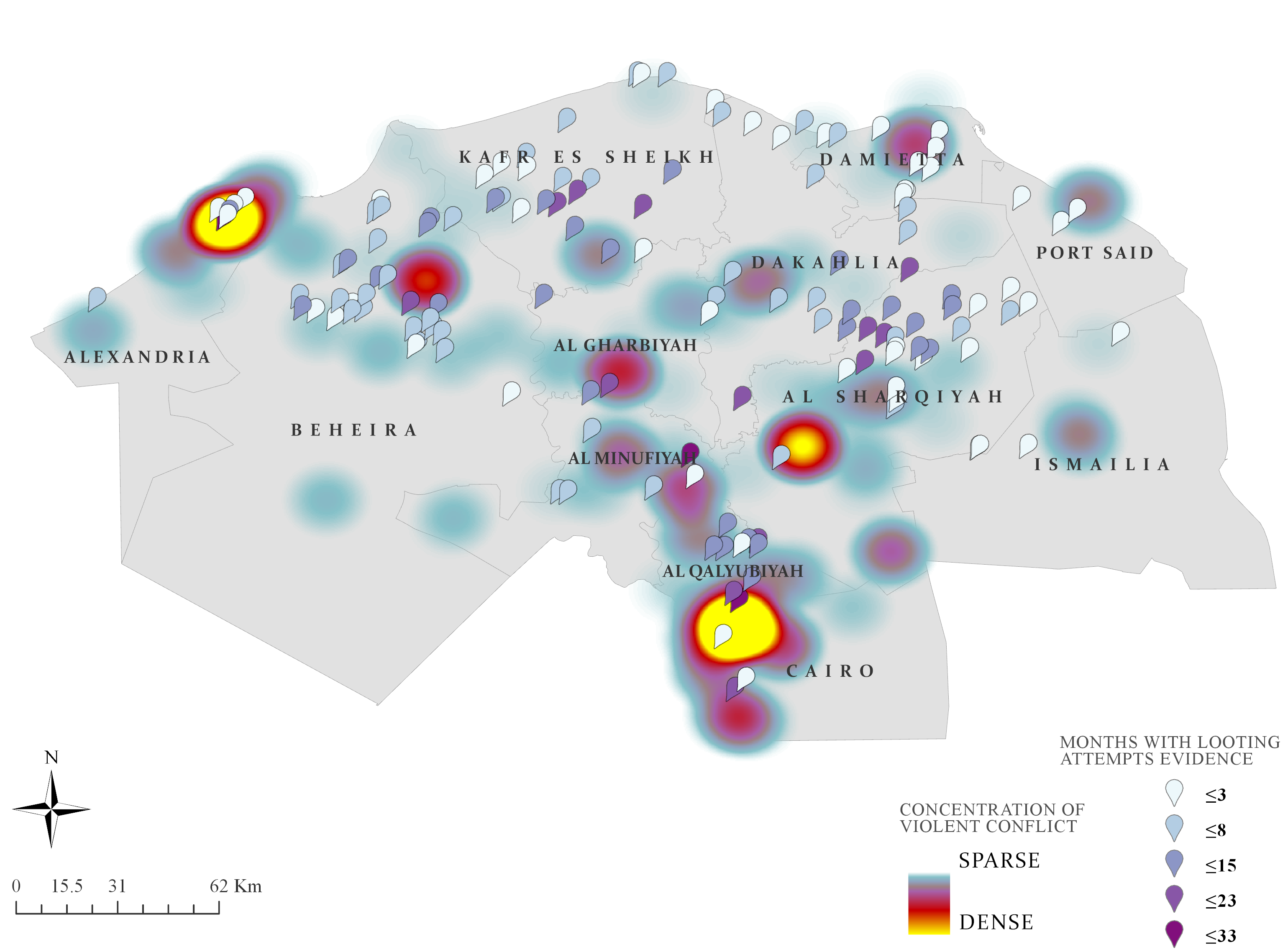
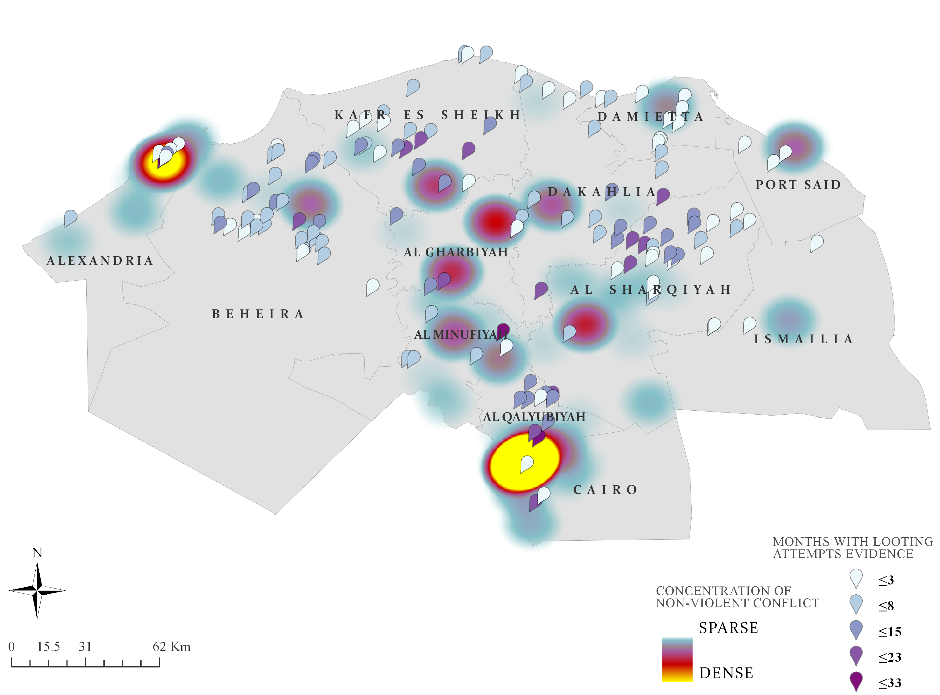
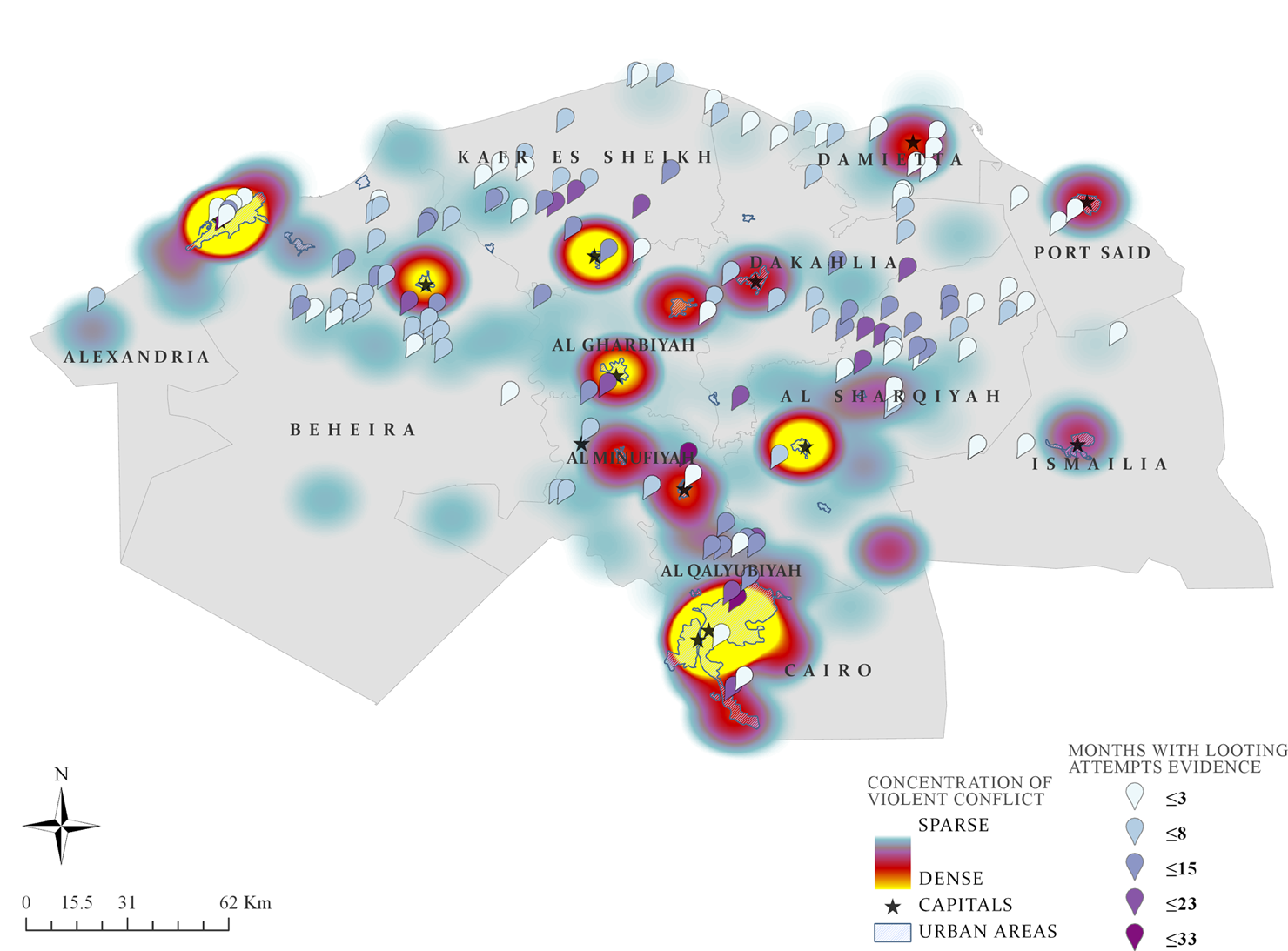
“The Space Between: Spatial Patterns of Archaeological Looting Attempts and Conflict in Lower Egypt”
by Michelle Fabiani

In Kate Burmon, Michelle Fabiani, and Saskia Hufnagel (eds). Cultural Property Crime and the Law: Global Perspectives.
2021
“Offender Motivations and Expectations of Data in Antiquities Looting”
by Michelle Fabiani

In D. Yates and N. Oosterman (eds.). Crime and Art: Sociological and criminological perspectives of crimes in the art world. Springer.
LEARN MORE
2020
“Archaeological Looting in Space and Time: Building a Baseline For Future Prevention”
by Michelle Fabiani

Michelle Smith Collaboratory for Visual Culture in the Department of Art History. November 13
LEARN MORE
2019
“Spatial and Temporal Patterns of Archaeological Looting: A Proposed Methodology for Data Collection and Analysis”
by Michelle Fabiani

American Society of Criminology Annual Meeting, November 13-16, San Francisco, CA.
2018
“Spatial and Temporal Patterns of Archaeological Looting in Egypt”
by Michelle Fabiani

Michelle Smith Collaboratory for Visual Culture in the Department of Art History. November 28.
LEARN MORE
“Contextualizing Archaeological Looting in Egypt”
by Michelle Fabiani

School of Architecture, Planning, and Preservation. October 8.
“Geographic Proximity of Armed Conflict to Antiquities Looting”
by Michelle Fabiani

Transatlantic Cultural Property Crime Symposium, June 28-29. London, UK. 
LEARN MORE
We study cultural property dynamics and community impacts.
University of Virginia logoUniversity of New Haven logoNational Science Foundation logo

Contact

Michelle Fabiani
Co-director
mfabiani [at] newhaven.edu

Fiona Greenland
Co-director
fg5t [at] virginia.edu